Directions to the Gateway Arch
Before you begin your adventures above and below the Gateway Arch, you must first find your way here! Whether you walk, roll, drive, or take public transportation, we are here to guide you to your day with directions to Gateway Arch National Park.

Drive
Find directions to the Gateway Arch from any of St. Louis’ convenient highways and bridges.
Exiting from Missouri Interstates 55, 44, 64/40 and 70
- I-44 East/55 North | Take Exit 292 for Lumiere Place Blvd/Washington Avenue/Eads Bridge, then take the U-turn from the left lane to access Pine Street and downtown.
- I-64/40 East | Take Exit 40 for the Last Missouri Exit. Turn left onto Gratiot Street, then left onto 4th Street. Continue north on 4th Street to access downtown.
- I-70 East | Take Exit 249B for Tucker Boulevard. Continue south on Tucker Boulevard, then turn left onto Market Street to access downtown.
Exiting from Illinois Interstates 55, 64 and 70 via Poplar Street Bridge, Martin Luther King Bridge, Eads Bridge and Stan Musial Veterans Memorial Bridge.
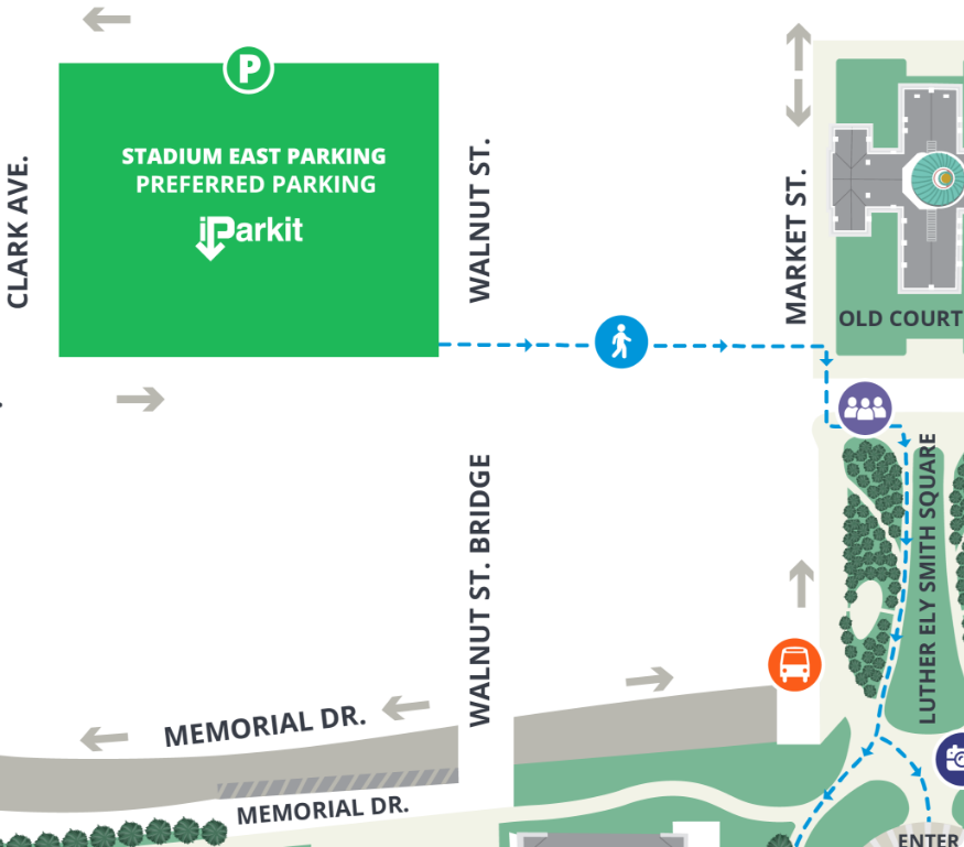
- Poplar Street Bridge (55 South/64 West) | After crossing the bridge, take exit 40B for Memorial Drive. Keep right on the exit and follow signs for Walnut St. Take a forced left onto Walnut Street to access downtown.
- Martin Luther King Bridge | After crossing the bridge, follow the road to the right, then turn left under the interstate onto Carr Street followed by an immediate left onto Broadway Street to access downtown.
- Eads Bridge | After crossing the bridge, continue straight on Washington Avenue then turn left on Broadway to access downtown.
- Stan Musial Veterans Memorial Bridge (70 West) | After crossing the bridge, take the left exit for North Tucker Boulevard. Continue south on Tucker Boulevard, then turn left on Market Street to access downtown.
Passenger Drop-Off/Pick-Up
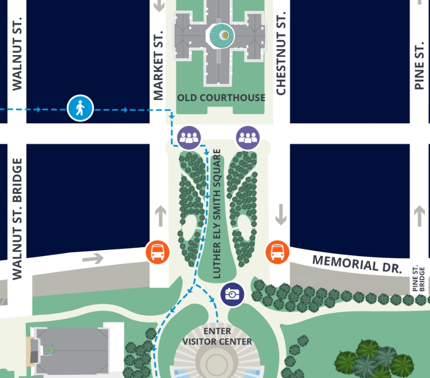
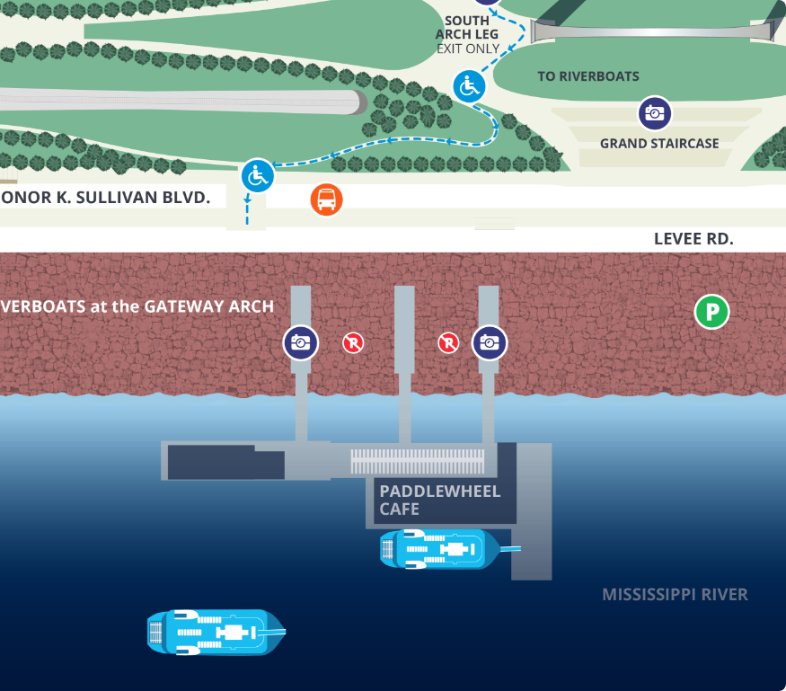
Enjoy convenient passenger drop-off and pick-up along Luther Ely Smith Square on 4th Street across from the Old Courthouse, between Market and Chestnut.
Pedestrians
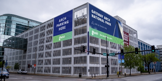
Gateway Arch National Park is a short distance from our preferred parking garage (7-10 minutes walk).
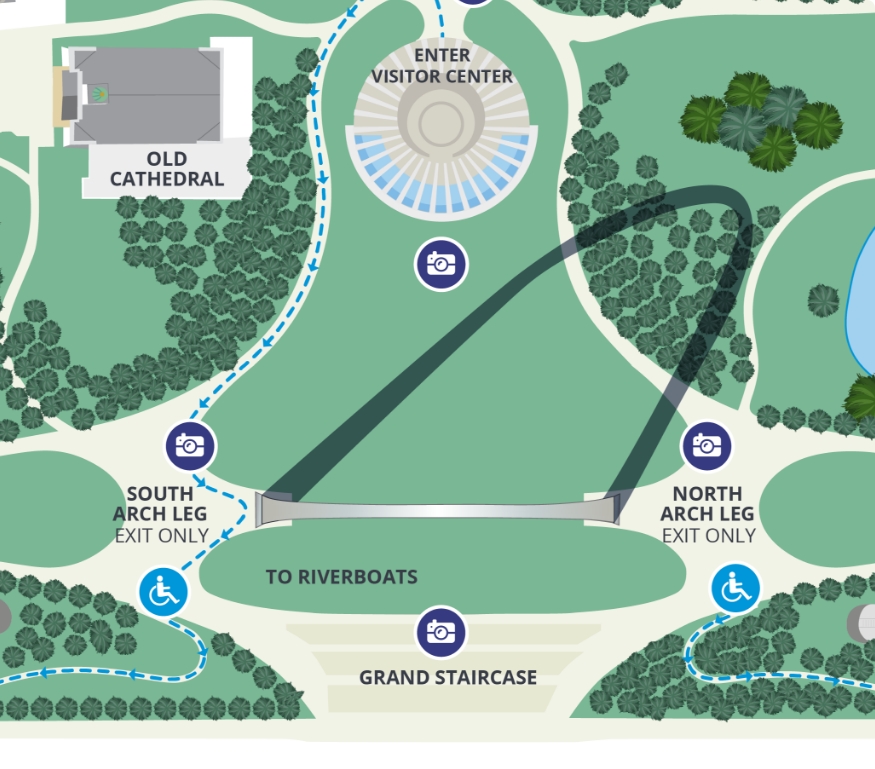
Accessibility Information
- Approaching from the west, all walking paths onto the Arch grounds from the City are open.
- From the east (on Leonor K. Sullivan Boulevard), use the Grand Staircase or the wheelchair accessible ramps from the riverfront to the park grounds.
- From the north via Laclede’s Landing, the 1st and 2nd Street entrances to the park are also wheelchair accessible.
- For additional information or assistance, please call our Call Center at (877) 982-1410.
Public Transit
Skip the drive and parking — take the MetroLink or MetroBus to get to the Gateway Arch.
MetroLink Train Station
- To find the MetroLink train station nearest you, visit the Metro Transit trip planner.
- Exit at the Laclede’s Landing station and walk (8 minutes) south through the park to the Gateway Arch entrance.
- Call (314) 231-2345 or email transitinformation@metrostlouis.org for more information about MetroLink or MetroBus.
MetroBus
- Refer to the Metro Transit trip planner to determine the best route to the Gateway Arch from your location.
- Call (314) 231-2345 or email transitinformation@metrostlouis.org for more information about MetroLink or MetroBus.

-
 Parking
 -
Accessible Ramp Entrance
-
Photo Opportunity
-
Pedestrian Route
-
Pedestrian Drop Off
-
 Accessible Pedestrian Route
 -
 Bus Drop Off
 -
Road Closed
-
Metro Link Station
-
No Parking
So Much Below in Gateway National Arch Park
From a short walk on our trails to an all-day adventure above and below the Gateway Arch, the possibilities are endless when you plan your visit. Wondering what there is to do? Take a look at our sample itinerary to see all to do in Gateway Arch National Park.
3 Days

A Long Weekend to Do Everything
Planning to visit St. Louis for a sporting event, family trip or weekend getaway? Get started planning your long weekend at Gateway Arch National Park and the St. Louis Riverfront with this itinerary.
View Itinerary1 Day

The National Park Adventurer
Great for national park enthusiasts! Spend a full day exploring the Gateway Arch, St. Louis Riverfront, Old Courthouse, and national park grounds with this comprehensive all-day itinerary.
View Itinerary4 Hours

An Evening on the Riverfront
Spend a few hours along the St. Louis Riverfront with an evening itinerary suitable for a date night, gathering with friends or girl’s night out.
View Itinerary5 Hours
Our Half-Day Essentials
Looking for more to do after taking your Tram Ride to the Top? This itinerary includes our free Museum, and Documentary Movie.
View ItineraryHave Questions Before Your Visit?
For tips to plan your day at Gateway Arch National Park, parking information, and more, explore our FAQs page to find all the information you need before you punch in directions to the Gateway Arch in St. Louis.